PinPoint Features

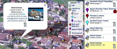
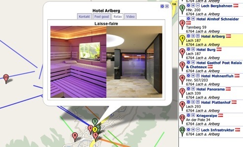
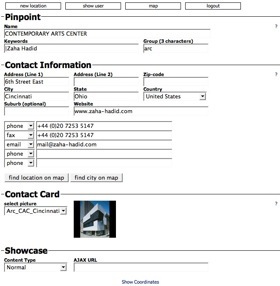
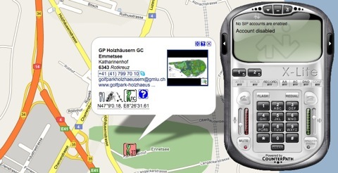
An information window, the business card, opens if a user clicks on a PinPoint on the map or in the list, but also if the company name or the graphical symbol  is used. The business card shows contact information, an image, text, e-mail addresses and communication links.
As soon as a user clicks the image it expands to fill the browser window. A slide show starts if there is more than one image attached to a location.
Directions to a location are activated if clicking the graphical symbol  . The route to the location is calculated and indicated after entering the place of departure and clicking the “Go” button.
If a user clicks the graphical symbol approach-zoom  on the business card or in the list, the map directly shows the vicinity of a location. The zoom level may be adjusted for each location individually.
The communication links, which are shown in a business card, activate installed systems, like Skype, Voice-over-IP, email, or websites automatically on the computer of the website visitor.
Existing web-applications, like contact forms or information about a location, can be attached to a business card as link that opens over the map. This reduces data administration significantly.
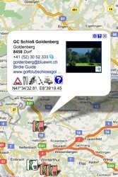
A PinPoint is a marker on a map that points out the location of any immobile object or event. All locations that are displayed on the map are also shown in a list on the right side of the map. Individual static or dynamic information and links can be attached to and displayed with any location.
The hover text shows address information if the mouse pointer hovers over a PinPoint.
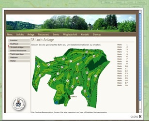
You can use showcases if you want to communicate location-specific information to the website visitor that exceeds the capacity of a business card. Showcases open if the user clicks the graphical symbol  in the business card or in the list. The contained information can be organised in tabs. Among text and images even videos, flash and webcams can be linked.
In order to keep the data administration simple, showcases can be standardized for several locations and can be linked with a database.
Graphics (lines, areas) can be embedded and displayed as well (KML). See below.
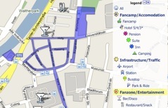
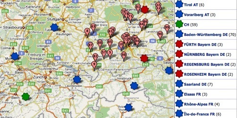
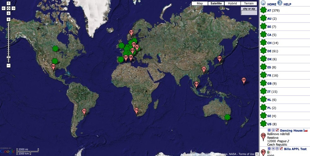
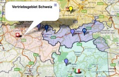
Clusters guarantee that the map is well organised:
-
 Country clusters can also be displayed using circles or flags (here we used a green marker)
 -
Regional clusters use blue markers in this example
-
City clusters are displayed here as ruby coloured markers
-
Individual locations use a pink location-marker on this map
Clusters are calculated and expanded automatically without need for configuration. The clustering can be fine tuned by your administrator. Alternative cluster-icons can be supplied.
Ideal Map View - Map Restriction
When a user opens the location-finder on a website the ideal zoom factor that fits all locations of a company on the map is calculated automatically. This can be the whole earth or only a town. When you add new locations this zoom adjusts automatically.
On request the area of the embedded map can be restricted to a predefined area and zoom range. Website visitors are not able to navigate outside the limits.
The map can be embedded many times on a website. Subgroups of the locations can be displayed in several maps on the same website.
When clicking the HOME-button the map resets to the original position.
Minimal Data Administration Effort
Depending on your IT-landscape you may have high data administration effort. We reduce your efforts to an absolute minimum.
Editor
Location databases, which rarely get expanded or modified, do not require a database connection.
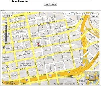
With easy to use online editors the data administration is easy. Locations, PinPoints and business cards can be created and modified by clerks who have the maintenance password. PinPoint reduces images to the required size automatically.
Right picture: In the editing mode the position of the marker in the map can be corrected by drag-and-drop. The map section shows your desired approach-zoom. Both map view (off-center) and zoom factor can be adjusted.
Database Connection
Dynamic location-networks, which get expanded or modified frequently, justify a database connection via XML. This avoids that your staff needs to learn a new application and connects PinPoint to an established system. This reduces costs considerable.
If desired, location data can even be downloaded and modified by means of a CSV-spreadsheet.
Automatically Generated Showcases
Showcases contain very site-specific information and structures. Showcase can be generated automatically on the basis of an existing database in your system. In some deployment scenarios they can even be hosted on your site.
Features


Website-Embedding
We recommend to embed PinPoint on your website large-sized or automatically adjusting. The ability of a user to recognize familiar structures improves with increasing size of the map considerably.
The integration of PinPoint in your website requires just a few minutes.
Custom-made Icons
Instead of the drop-style location markers you can use individually designed markers (approx. 32x32 pixel). You can provide your self designed icons, or you choose among icons in various styles and colors provided by WEISSWO.
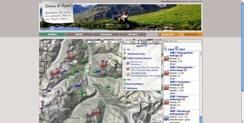
Legend
The same icons are also used to create a legend. After clicking on a legend item, the map and list show only locations that match the selection. Locations can have different features. For example, a hotel can be selected through accommodations, restaurants and bars.
Search Function
A swift search text field is integrated at the top right corner of the map. Optionally it can be embedded at other locations. Only selected locations are displayed after entering the city name or the zip code. The search result is reset after clicking another icon in the legend, using “HOME” or clearing the box.

Picture List
It is time consuming to read comprehensive attributes. The ideal method to communicate some features are pictures:
-
Design/Appearance
Buildings of architectural interest, exhibitions, etc., as well as objects with a crucial image. -
Tourism
Beside the appearance of the accommodation, sceneries influence the choice of a vacation resort. -
Information content
-
It is time consuming to study descriptions of complex objects. Optical criteria are communicated with pictures most suitable. You grab the attention of your web site visitors.
The requirements for location finders vary from business to business. Often one needs to find the closest location offering a specific product. This applies if the range of products/services of an enterprise recurs at different locations, as in the tourism industry. In this case, distinctive features arouse interest and consequently influence the choice of location.
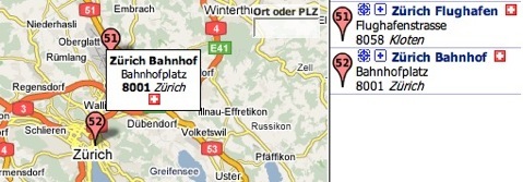
By means of the swift-search a location can be found with only fragments of information.
A location is found by means of the name, the city-name or a zip code. The input of 3 characters is enough to list all locations which contain this character string. The result in the list reveals even those which are currently beyond the visible area of the map.
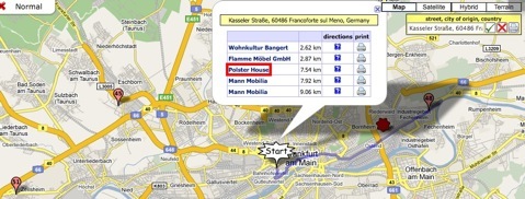
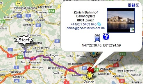
The vicinity-search or radius-search is ideal for persons who look for a location in an unknown region, where they neither know surrounding place-names nor zip codes.
After input of any start-location, nearby locations are listed with approximate distances. If the place is inaccurate the start-icon can be moved by drag-and-drop to a new position.
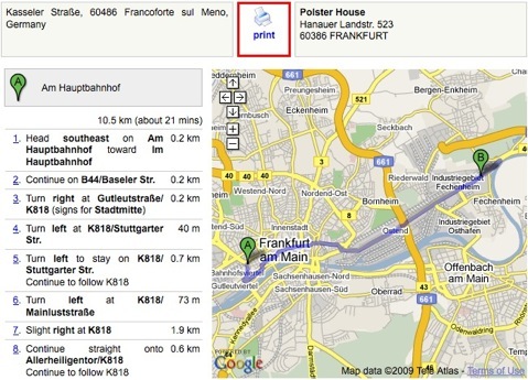
When clicking a result the route is calculated and indicated as a blue line. The user has the option to print the result (see below).
When clicking the print symbol in the vicinity-search window the print preview opens.
The page shows a customer specific banner on the top of the page, the start- and destination- address, a route description and two windows with maps of the route.
The maps are interactive. Website visitors can adjust the maps before printing them.
The print page can be configured customer specific.
Site Specific Information
Another alternative to communicate location-based information without additional data maintenance is provided through IFrame links.
Contents, which are maintained on any other website, can be linked to the business card. When clicking the link the information is displayed inside an IFrame above the map. Even interactive contents can be embedded.
Existing web applets are online without delay. Redundant data maintenance becomes history.


Webcams show current pictures. The webcam view also displays permanently a picture in the list while other locations display address information as usual.
Thus, a website visitor gets a quick overview already when scrolling through the list.
Full Screen Mode
Older browsers, content management systems, or user screens with low resolution result in fixed width web designs. Users with up-to-date hardware cannot use such a design fully and screen space that is very helpful in navigating a map is wasted.
A user´s ability to recognize structures on a map is improving with it´s size. It is essential to recognize big structures as well as details. Especially locating a position relative to a big city needs space.
The „full screen“ mode is a remedy. Irrespective of the size limitation of a website, a visitor can enlarge the map to the desired size by clicking the „maximize map“ button (Vollbildmodus). The map shrinks back into its original spot by clicking the „minimize map“ button (Normalbild). The full screen function has no impact to the website functionality. The functionality is embedded into a website by its administrator as little JavaScript program. The webmaster can adjust look and feel, button texts and menus as needed.
Special Functions


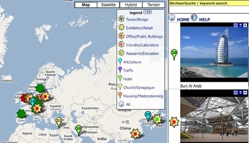
External Content Layers
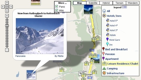
With PinPoint you are able to show articles of the free encyclopedia Wikipedia or the photo-sharing community Panoramio. Youtube videos may become available soon.
Information layers that Google provides can be embedded into the location-finder or upgraded at a later point.
Via the button „More ...“ the layers can be activated or removed. A click onto the icon opens the text information respectively zooms the picture.

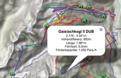
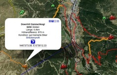
Graphics/Lines/Areas - KML
Graphics are applicable versatilely. They can be used as supplementary information or as independent information:
-
Marking of areas/zones
parking areas, event zones, etc. -
Highlighting bounds
-
Boundaries and areas improve some map applications. The transparency of colored highlighted areas can be adjusted.
-
Indication of lanes/routes
-
Trails, bicycle routes, cross-country ski runs, competition tracks, etc. can be integrated in user-defined colors, line-thickness and transparency.
-
Indication of structures/buildings
-
Some structures are hardly to see or not at all. They can be indicated by means of a graphic.
Graphics/KML can be created in Google Maps or Google Earth or be tracked with a GPS device and transfered to PinPoint.
Graphics can be permanently visible in a map or can be activated via an individual icon or a category-icon in the legend.
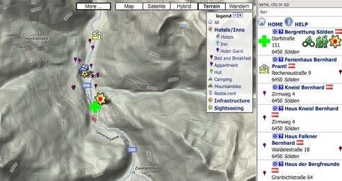
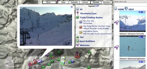
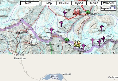
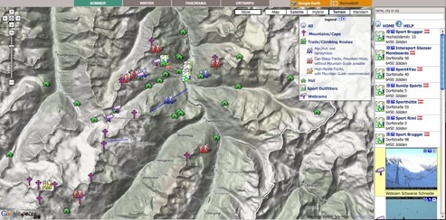
Custom Maps
Some organisations like to provide more detailed map information than provided by Google. By embedding thematic maps into the Google map useful information can be communicated especially in rural areas where the Google Map is sparse.
Such maps replace all or parts of the Google Map. The locations are congruent in all presentation modes.
Beside the buttons „Map“, „Satellite“, etc. a site specific map layer is activated by a custom button “Wandern” (hiking; demo available in German language only). A website visitor is able to switch to the thematic map via this button.
Map amendments and embedding of additional information can be carried out in the Google-map directly for customer applications.
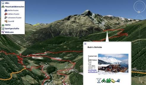
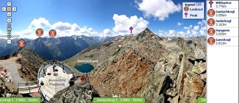
Panoramas - Leap function
Panorama-pictures and panorama-maps supplement the location information in the map for some applications. An aerial view conveys the website visitor additional impressions of locations, which get shown in the Google-Map. Due to optical distortions the locations are not georeferenced. However they can be linked with the locations in the map.
Beside conventional location markers PinPoint integrates also special markers into panoramas. The mountain panorama to the right was taken at a certain position. The place name can be seen at the lower image border. The round icons in the panorama show other places where panoramas were taken. If you click one of these leap-icons the view moves to the corresponding position and shows the perspective from there.
The intuitive Google Maps operating philosophy
is realized with all pictures and panoramas. Even images with some 600MB and more can be easily moved and zoomed.
Google Earth
If landscapes are important for your business, they can be presented with PinPoint`s Google Earth converter. Google Earth offers the possibility to observe landscapes from all perspectives.
A click on a button embedded into your website starts Google Earth. Location information and graphics are converted by PinPoint and immediately downloaded to Google Earth.
Data publishing to maps.google.com
In order to be found in Google-Maps and Google-Earth, PinPoint locations can be published with the current location information on demand.