Clearness

Several measures contribute to get the result with very few clicks.


Concurrency
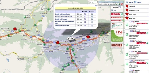
All locations get despatched concurrently with all information. The decision for a certain area does not eliminate neighboring locations. They are still on the map.


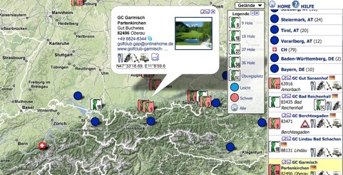
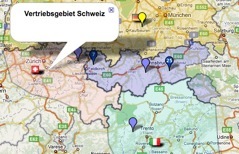
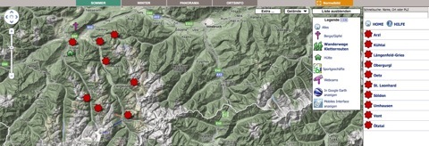
Clustering - with 3 clicks to the information
Locations which are allocated to the same geographic area get clustered automatically depending on the zoom level. There are three zoom levels:

  1. Country cluster can be shown with a green marker, circle or flag (arbitrary)

  2. Region cluster: e.g. blue marker

  3. City cluster: e.g. ruby marker

  4. Individual location: Individual customer icons

Cluster icons can be marked with markers provided by the customer.
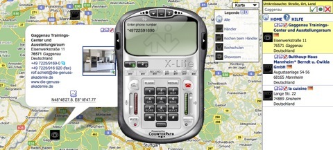
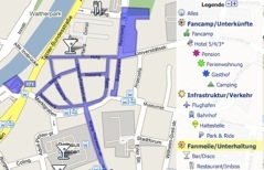
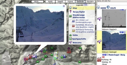
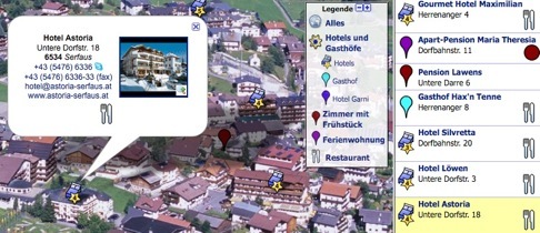
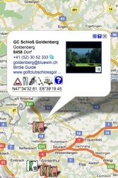

Legend
When clicking a category in the legend map and list show only locations, which are allocated to the corresponding category. One location can be allocated to several categories. The categories can be displayed in the business card and the list entries.


Full screen mode

A user‘s ability to recognize structures on a map is improving with its size. It is essential to recognize big structures as well as details. Especially locating a position relative to a big city needs space.
The „full screen“ mode is a remedy. Irrespective of the size limitation of a website, a visitor can enlarge the map to the desired size by clicking the „maximize map“ button (Vollbildmodus). The map shrinks back into its original spot by clicking the „minimize map“ button (Normalbild). The full screen function has no impact on the website functionality. The functionality is embedded into a website by its administrator as a little JavaScript program. The webmaster can adjust look and feel, button texts and menus as needed.

Coverage of all search patterns

Each person follows his or her personal searching logic. PinPoint covers all of them synchronously.


Map search

For the majority the geographic search is easier in maps than in lists. In particular in unfamiliar regions where you neither know place and street names nor postal codes.


List search

Mathematically inclined thinkers prefer the search in lists. All locations shown in the map are shown in the list synchronously. If the map is moved, the list gets refreshed accordingly.


Vicinity search

Some people know where they are or where they want to go. After entering the start position the closest locations get shown and listed, indicating the distance. The start position can be moved in the map by drag & drop. The route description can be printed out together with map views.


Swift search

For some applications the swift search for name, place name, postal code is suitable. Entering 3 characters starts the search for matching results, which are shown even if they are outside of the displayed map area.


„My Location“

Alternatively the vicinity search can be started via the function „My Location“. The approximate position of the IP address gets localized and marked. The closest locations are listed by distance.

Location information - Business card

The choice for a location depends on the services offered. Mostly the closest location is of interest if the offered services are similar. The choice of different services for the location depends on meeting the demands.
PinPoint gives a rapid survey of the location related services.
The business card opens if clicking a Pinpoint in the map or the list. It provides useful information and functions beside the mandatory contact information, like e-mail, address, communication links and text:


Features/categories - Legend

The services, offered by a location, are indicated with icons. This information is also available in the list. In the legend they get described.


Location information in the map (Lytebox)

Extensive contents, which get maintained in any in- ternal or external website, can be displayed on the map by means of the Lytebox function. Without additional efforts you provide the visitor all informa-tion without the necessity to change menus and to open new browser windows.
Amendments are online instantly. Data administration is not applicable.


Image zoom/slide show

If clicking an image it expands to its original size. A slide show starts if there are several pictures.


Route calculation with print function

The route calculation is activated when clicking the graphic symbol
. The start icon can be moved by drag-and-drop to a new position. The route is indicated as a blue line in the map. The print preview shows the description and two interactive maps, which can be adjusted individually before printing.


Skype, VoIP

Clicking on a telephone number or the Skype-symbol activates the corresponding systems at the visitor‘s computer if they are installed.


Approach zoom

The map section which displays the vicinity of a location gets shown when clicking the symbol approach zoom
  in the business card or the list. The zoom level can be adjusted individually for each location.
 

Individualization - Corporate Design


Corporate design

Websites are unique. PinPoint gets adapted to the corporate design of a website.


Individual icons

Location icons for the map and category icons for the legend, provided by the customer, get furnished with appropriate shadows in order to accentuate the three-dimensional effect.
Alternatively you can select icons out of the WEISSWO standard range.

Graphics/lines/areas - KML

Graphics can be applied in many ways. They can be used as self-contained as well as complementary information:


KML/routes/tracks

Hiking- and bicycle tracks, cross-country ski runs, competition routes, etc. get integrated in individual colors, thickness and transparencies.


Areas

Parking sites, event areas, etc.


Boundary mark

The highlighting of boundaries and areas improves the overview for some applications. The transparency of colored areas can be adjusted.


Graphics/KML can be drawn by the customer in Google Maps/Earth, recorded with a GPS tracker or transferred from a different source and integrated in PinPoint.

The graphics can be combined directly with a map or get activated by an individual icon or a category icon in the legend.

Special Functions


Image list

Images communicate some properties better than comprehensive descriptions. For instance architectural interesting buildings, exhibitions, etc. as well as reference objects where the formal appearance plays a major role.

External layer

The Google Maps contents Wikipedia, Panoramio, videos, etc. can be overlaid as layer. They get faded in and out with the button „More/Mehr“.

Web cams

Web cams show current views. The views are displayed at the camera position in the map and the list.

Google Earth-converter
Beauty spots ought to be played to the gallery as manifold and diversified as possible.
With Google Earth landscapes can be viewed from all stereoscopic perspectives. Google Earth is started via an embedded button. Location information and graphics get transferred by PinPoint and displayed in Google Earth.

Internet - Data publication

In order to be found in Google Maps and Google Earth PinPoint locations get published if desired.

External maps/aerial images

Some applications need detailed maps. E.g. it is possible to communicate comprehensive additional information by embedding topical maps into Google Maps.
The maps get equalized and integrated behind the location information. Locations are congruent with each other in all presentations.

Visitors can select the map via a new button, which gets integrated beside the buttons „Map“, „Satellite“, etc.

Additional map information and corrections can be rendered in the Google map directly.

Panoramas - leap function

Panorama-pictures aerial views convey the website visitor additional impressions of locations, which get shown in Google Maps. Locations, which are shown in panoramas as well as in the map, get linked together. Visitors have the option to see a location in different media.


Leap-spots are markers by means of jumping from one outlook to another one.

The mountain panorama below left was taken at a certain position. The place name can be seen at the lower image border. The round icons in the panorama show other places where panoramas were taken. If you click one of these leap icons the view moves to the corresponding position and shows the perspective from there.


The intuitive Google Maps operating philosophy is realized with all pictures and panoramas. Even images with some 100MB and more can be easily moved and zoomed.

Map restriction

When opening the location finder on a website the ideal zoom factor that fits all locations of a company on the map is calculated automatically. This can be the whole earth or only a town. When you add new locations this zoom adjusts automatically.

The embedded map can be restricted to a prede-fined area upon request. Website visitors are not able to navigate outside the limits.

The map can be embedded many times on a website. Subgroups of the locations can be displayed in several maps on the same website.

When clicking the HOME-button the map resets to the original position.


The demands on a location finder are manifold. The development and the ongoing data maintenance are very elaborate. The demand gets often underestimated. Many corporations omit to integrate a beneficial product.

PinPoint comprises many years of experience and development, which inure to your benefit.


Compendium of Functions


Clearness

Despatch of all locations

Automatic clustering

Intelligent interactive legend features

Full screen mode


Coverage of all search patterns

Map search

List search

Vicinity search

Swift search

„My Location“


Individualization - Corporate design

Individual icons


Location-information - Business card

Business card

Integrated Route calculation with printing function

Location information in map (Lytebox)

Image zoom/Slide show

Communication systems: Skype, Voice-over-IP


Graphics/lines/areas - KML

KML/routes/tracks

Areas

Boundary marking


Special functions

Picture list

External layer: Wikipedia, Panoramio, videos, etc.

Internet - Data publication

Web cams

Google Earth converter

External maps

Panoramas - Leap function

Map limitation